Author:
Janice Evans
Date Of Creation:
28 July 2021
Update Date:
23 June 2024

Content
Pilots use aeronautical meteorological codes (METAR code) to transmit actual weather reports at the aerodrome. To the casual reader, this summary looks like a bunch of random numbers and letters. In this article, you will learn how to decrypt such a summary.
Steps
 1 Get a summary. WikiHow took as an example a summary showing the weather conditions at the United States Air Force Academy. The content of this summary is as follows:
METAR KAFF 212355Z COR VRB05KT 15SM FEW040 SCT060 SCT075 SCT090 BKN220 15 / M01 A2957 RMK ACSL DSNT SE-S SLP960 SHRA DSNT N-E-SE AND DSNT NW 60001 55000 LAST COR 0043
 2 Determine the type of summary (METAR). This could be:
 - METAR = standard hourly summary; or
- SPECI = Special Out of Schedule Bulletin.
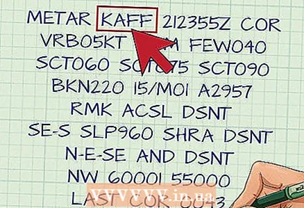 3 Note the station ID (KAFF). K is a prefix used to indicate locations in the Continental States. AFF is the airfield of the Air Force Academy. International symbols for METARs are published by the World Meteorological Organization (WMO). For example, EGLL is used for London Heathrow Airport, RJAA for Tokyo Narita Airport.
  4 Pay attention to Time / Date (212355Z). The first two digits are the day of the month, the subsequent ones are UTC (Coordinated Universal Time). This summary was taken on the 21st at 2355 UTC (1755 local time). Note: The summary does not include the month or year.
  5 Look at the modifier (COR). It can be of two types:
 - AUTO = automatic station;
- COR = Corrected Automatic Summary.
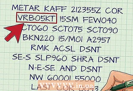 6 Check the wind information (VRB05KT). The first three digits indicate the true wind direction (from where it is blowing) or, if the wind is erratic, indicate "VRB". The next two numbers show the speed in knots. If there are gusts, the highest gust speed is listed after the wind speed. For example, winds that blow from the north at 7 knots and the highest gust speed of 15 knots would be designated as "36007G15KT".
  7 Check ground visibility (15SM). Dominant visibility is measured in charter miles (SM). Fractions are separated by a space, 1 1 / 2SM. Runway supplemental visibility (RV) is reported as R, followed by the RV selected, the forward slash (/) and the visual range in feet at that runway.For example, R36L / 2400FT indicates a range of sight of 2400 feet at GDP 36 left.
  8 Look at the Current Weather (it is missing in the example). This may include one or more of the following phenomena: Intensity, Descriptor, Precipitation, Blackout, and others. See the table below:
* Automatic stations only For example: light snow will be designated as -SN, heavy thunderstorm + TSRA, moderate drizzle FZDZ, etc.Intensity Descriptor Precipitation Blackout Other - Light MI Thin DZ Drizzle BR Haze PO Dust / Sand Vortex Moderate (no intensity designation) BC Scraps, shreds RA Rain FG Fog SQ Squalls + Strong DR Drizzle SN Snow FU Smoke FC Funnel cloud VC Close BL Blowing blizzard SG Snow grains DU Dust + FC Tornado or Waterspout SH Showers IC Ice needles SA Sand SS Sandstorm TS Thunderstorm PL Ice croup HZ Haze DS Dust storm FZ Freezing GR Hail PY Water dust PR Partial GS Light hail and / or snow pellets VA Volcanic ash UP Unknown precipitation *  9 Pay attention to Cloudiness (FEW040 SCT060 SCT075 SCT090 BKN220). The first three letters indicate the amount of clouds.
 - SKC = Clear (non-automatic summary);
- CLR = Clear (automatic summary);
- FEW = Few (1/8 to 2/8 of the sky is cloudy);
- SCT = Scattered (3/8 to 4/8 of the sky is covered with clouds);
- BKN = Broken (5/8 to 7/8 of the sky is covered with clouds);
- OVC = Solid (the sky is completely cloudy).
These values represent the height of the cloud base in hundreds of feet above ground level. The maximum level is the lowest cloud layer and is referred to as BKN or OVC. In this example, the maximum level is 22,000 feet.
 10 See Air temperature / Dew point (15 / M01). These values are indicated in C °. 'M' means minus.
  11 Check QNH Pressure (A2957). This is the atmospheric pressure at sea level and is expressed in inches of mercury ("Hg). For example, A2957 = 29.57" Hg. Pilots use this information to make sure their altimeter is at the correct altitude. 29.92 is the standard.
 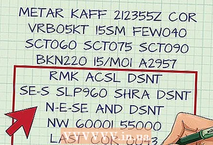 12 Please note the Additional Information (RMK ACSL DSNT SE-S SLP960 SHRA DSNT N-E-SE AND DSNT NW 60001 55000 LAST COR 0043). Any additional information can be helpful, such as when the thunderstorm started or ended, the type of station, the pressure at sea level, the temperature down to tenths of a degree, etc. In the example:
 - ACSL DSNT SE-S = Altocumulus lenticular clouds in the distance southeast through south.
- SLP960 = Sea level pressure (in tenths of hectopascals) 996.0hPa.
- SHRA DSNT N-E-SE AND DSNT NW = Moderate rainfall in the far north through the east and southeast and in the far northwest.
- 60001 55000 = cumulative and automatic maintenance information.
- LAST COR 0043 = last correction made at 43 minutes of the current hour.
 13 Find local airport bulletins. Use the links below to find the METAR for your airport.
Tips
- Find your airport and practice reading METARs, then compare them to weather conditions.
- NAV Canada has an excellent METAR site [[1]]


